2009年6月4日 星期四
Geotagging Picasa photos in Google Earth
Geotagging Pictures in Google Earth: Geotag a photo
Picasa lets you match your photos to a specific location using Google Earth. Geotagging your photo does the following:
1) Embeds location information within your photo file.
2) Displays your photo on a satellite map rendered by Google Earth.
To geotag a photo, follow these steps:
1) Select the photo in Picasa.
2) Click the Geotag button in the Photo Tray. Google Earth opens up and a small Picasa window appears in
the lower-right corner.
3)Navigate and zoom to the location in Google Earth that corresponds with where your picture was taken,
and place the yellow cross-hairs on your chosen spot.
4)Click the Geotag button to place the selected photo. You can also click the Geotag All button to tag all of
the selected pictures with the same location information.
5)When all of your pictures are geotagged, click the Done button to finish the placement.
6)When you exit Google Earth, click the Yes button to save the geotagged locations in your 'My Places'
folder. You'll then be able to access the photos in 'My Places' any time you open up Google Earth.
Google Earth

Google Earth is a program, which provides us interactive maps of any part of Earth. These maps are actually processed from real satellite images. Thus, they are actually real photographs of different places on Earth. Thus what you see in these maps is exactly similar to what the place would have appeared, if looked from sky.
Latest version : Google Earth 5.0
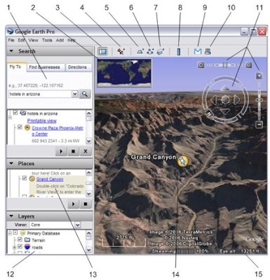
1. Search panel (搜尋欄) – Entering the address or coordinates that you want to find
2. Overview map (地球全景) – Display the certain part of the Earth
3. Hide/Show sidebar (顯示/隱藏側欄) – Click to show or hide the sidebar
4. Placemark (加地標題) – Click to add a landmark
5. Polygon (多邊形) –Can add a polygon on the map, with CD-Plus version limited to the above
6. Path (路徑) – Can set a path on the map, with CD-Plus version limited to the above
7. Image Overlay (影像圖套疊) – Can stack the images on the map
8. Measure (度量) – Can measure the length of a straight line or route, with an area measuring pro version
9. Email (郵寄) – Can send email to others of .kmz file
10. Print (列印) – Can print the current screen map
11. Navigation controls (導航控制) – Functions including zoom, tilt and rotate functions
12. Layers panel (圖層夾) – Can check and display the various layers (POI)
13. Places panel (地標夾) – Can display a variety of topics (Landmark), and can be edited and saved
14. 3D Viewer (主畫面) – Appear the Earth's terrain and its various theme
15. Status bar (狀況欄) – To display the mouse coordinates, elevation view and download of the streaming case
2009年6月3日 星期三
訂閱:
意見 (Atom)


